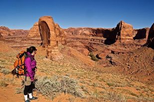
 Maggie Looking into Escalante Canyon
 We cautiously approach the edge of the precipice. The rolling slick rock drops away into the Escalante River Canyon. The canyon snakes through the desert plateau, with the Stevens Arch on the far side staring at us like a serpent's eye. It's my girlfriend Maggie's and my aim to hike up Coyote Gulch, one of the Escalante's main tributaries. But we are momentarily paralyzed by the landscape into which we will descend, and I can't help but wonder if we are making a huge mistake.
We find the "Crack in the Wall," where a section of the rim has cleaved a foot away, creating a narrow entrance. We body belay our packs with a rope over the lip to a flat spot below, then scramble down the tight passage, shoulders scraping the rock on either side. The corridor opens up into the desert sun, and I am struck by how far I am from the forested mountains of my native Cascadia. Here, I am out of my element. While I am thrilled to have my beautiful backpacking novice girlfriend, I feel an underlying trepidation. In the many miles before us we will need to find potable water, route find up the creek and over rocks, and then make an exposed climb back to the rim. I fear being chastised, on online news comment sections, for being another tourist underestimating the desert, and getting himself and his girlfriend in over their heads.
A steep, sandy descent leads us to the gulch's entrance a half mile above its confluence with the Escalante where we step into a desert eden. Dragonflies buzz about our heads, and butterflies flit in the morning sun. We don our neoprene socks on sunny sandstone slabs under cottonwoods, and begin tromping up the creek. Coyote Gulch shatters our preconceptions of what entitles a “gulch.” This is a massive canyon with grand, sheer walls.
 View of the Cliff Arch from our Camp Site
 The plateau above the rim is fortressed by a striated backbone of rock that stretches out of view on either side, and reaches a thousand feet into the sky, with the less than inspiring title of the "Straight Cliffs." Sagebrush plains shed seasonal downpours, spawning the potential for torrential flash floods. This region is the southeastern domain of Grand Staircase Escalante National Monument (GSENM). Twice the size of Rhode Island, GSENM, where a pit toilet is a rare find, feels like the wild west.
Lesser known than its world famous neighbors of Bryce and Zion, GSENM forces you to earn your vistas. This transforms the visitor from passive tourist to intrepid explorer, where each waterfall and arch are discoveries, not mere points of interest along a designated tour.
Coyote Gulch twists and turns, revealing a new majestic desert tableau around each corner, beckoning the wanderer to venture further. The creek’s oxbows have carved out enormous amphitheaters, creating half domes overhead. Several times we must scramble around short waterfalls, at times necessitating some creativity. We tie paths from bank to bank, and sometimes tromp straight up the creek.
The November sun falls behind the encapsulating horizon, and the air quickly breathes cold. We keep closer track of water seeps as our supply runs lower, and we must find a camp soon. Searching for reliable water is never a problem in the Northwest, and I haven’t felt compelled to filter my backcountry water there for years. Here, a constant drip is an oasis.
Finally, we round a bend and see the massive Cliff Arch protruding obliquely from the canyon wall. We drop anchor on a sandy spot adjacent to the creek where a ten foot waterfall pours off a broad slab of sandstone. Behind us, we can see straight through the cliff arch, and the desert has further blessed us with a prodigious spring only ten yards away. I observe my inward relief externally mirrored on Maggie. She has been a great sport all day. The discovery of this beautiful site serves as an ample reward for our efforts. We sleep out, watching the full moon rise over the rim, transforming the russet walls to bright bone white.
 The Creek Flowing Under Coyote Arch
 We dust ice crystals off our sleeping bags in the morning.
As new as navigating the desert is for me, all of this is new for Maggie. Another first for her is using the portable toilet that the Ranger Station issued us for free. We pass one another coming to and from the cottonwood grove near our camp. I cheers my full bag with her empty and we joke that this is the only trip where our packs get heavier.
Carrying your waste is rarely necessary at home. Coupled with these unaccustomed challenges is an array of desert dwellers to elicit all manner of phobias; snakes, spiders, and scorpions to name a few. However irrational those concerns may be, there is the very fierce nature of this landscape’s flora. The tenacity required for anything to grow in this environment necessitates defenses manifested in the forms of thorns, needles, and spikes. One ubiquitous ground shrub produces seeds resembling tiny morning stars that compulsively seek out the spaces between your toes, and the all too vulnerable surfaces of your sleeping pad.
We grit our teeth and pull on our partially frozen neoprene socks. We keep a quick pace upstream to stay warm, while watching the sun’s light unravel agonizingly slow down the canyon walls. Not much further, we encounter where the creek flows right under Coyote Arch. We pass beneath in total awe of our location. It’s odd that a place with such a scarcity of water, can be the greatest evidence of water’s power and persistence.

Several jaw dropping corners later we come upon the Jacob Hamilin Arch, the most impressive desert edifice along the journey. We are so enthralled by the arch, that we blow right past our exit point and continue around. We realize our mistake, but have no regrets, as the great amphitheater and arch of that particular bend is the Desert Southwest in all its glory.
When we finally scope our exit, a 150’ sandstone slab, I attempt to stoke up Maggie, despite my own misgivings. The first pitch is easy enough, with bomber hand and footholds. It benches out slightly before rising into slabby exposure. We brought a rope, but to our surprise, one is already hanging down the steep face. At the time, I was a little disappointed, having looked forward to the challenge of soloing the climb and fixing a rope. But when it was all over, I was grateful for the rope’s security.
We continue with our packs on, following a path of narrow dishes, etched out by the ancient tools of the indigenous people here centuries ago. Now eroded into smooth indentations, they provide some traction up the face.
I coach Maggie along. As she climbs over a particularly exposed section, one hand gripping the rope, her foot slips out from under her. Everything slows as I see her shoe lose contact and her weight swing away. She maintains her grip on the rope and manages to remain affixed to the face. However, her gaze is locked upon the rocks below.
“Do not look down,” I tell her, as calmly as possible. “Two more moves and you are on this ledge.”
She focuses, and scrambles onto the sloping ledge. The climb remains steep and sparsely featured for another pitch, but with assiduous effort, we both reach the top and make the final climb to the rim. We embrace and survey the landscape that we just ventured through. But we still must find our way back across the rolling slickrock to our car.
I bust out the map and compass, eager to dust off skills I have not required in years. As soon as I get an angle on our route, Maggie points out the overly established line of cairns leading us all the way back. I laugh and feel compelled to point out that despite the cairns, I could have gotten us back.
“I believe you,” she says with a sly smile, but I could tell she was grateful for a rock solid route back to the car.
 RSS Feed